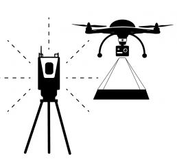


Laser scanning
When it comes to laser scanning and 3D laser scanning we have vast experience in the industry. In 2004, as one of the first in the Nordic countries, we invested in a MENSI GX 200 3D laser scanner. The investment of technology made it possible to efficiently and quickly get accurate as-built documents in 3D-laser scanning for existing industrial plants. Today we use Riegel VZ-400 for 3D laser scanning. The equipment known for its high precision is suitable for scanning industrial plants, buildings, roads, tunnels and terrain to name just a few uses. To get optimal results from the scan projects, we also use other measuring equipment such as UAV helicopter and GPS as well as accurate total stations. Starting each project with accurate measurements and 3D laser scans ensures that everything is right from the start, saving you time, money, and unnecessary work. For example, a detailed and realistic 3D model helps architects already in the planning stage get accurate source data. Our scanning services are flexible and customized, and we offer both support and free viewing software for our clients. Our 3D models with point clouds are accurate, fast and affordable. We can work on everything from smaller items to major industrial plants. In the design programs with point clouds, we can make updates, analyze detail and factory models, and measure actual deviations. Our services allow you to step from paperwork straight into a world of 3D. We also have the opportunity to combine UAV with laser scanning material and with our long experience and high level of expertise, you can be sure of an exact result every time.
Do not hesitate to contact us if you have any questions about our measurement services. We will be delighted to tell you how we can facilitate your work!
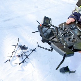
UAV
UAV photography, or laser scanning, is a fundamental part of the execution of any earthworks project, which, without accurate calculations, would be very difficult and time-consuming. UAV-mapping from the air shortens work-time and enables the creation of DSM point-clouds and geo-referenced orthomosaics. The surface model created from the point map is used efficiently, for example as a basis for the plan or volume calculations. All Ostromap's experienced staff have engineering training and substantial experience in modelling services.
ProcedureThe abbreviation UAV refers to an unmanned aerial vehicle, also known as a drone, which can fly without a pilot on board. The drone is remotely controlled by an operator from a ground station using radio communications. The flight is mainly automated, and the ground station controls the drone by using satellite location. Aerial photography may be carried out at a maximum of 150 metres without special permission in areas that have no flight restrictions. However, regulations vary from region to region. We are fully cognisant of the legislation concerning UAV, and we can, therefore, execute flights safely and according to the law.
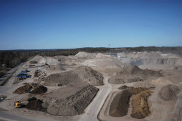
Fields of application UAV flight measurement enables the collection of terrain data faster and more economically than from the ground level. The size of area can range from a few to several hundred hectares. UAV flight measurement has many uses - the applications are almost infinite. If you have a particular idea in mind, we can definitely implement it together. The most commonly photographed objects are areas where you need to perform volume calculations, such as gravel deposits. It is also easy to conduct maintenance inspections of various difficult facilities through UAV airplanes' photogrammetry, without compromising anyone's health. Aerial photography can also be performed to produce point-cloud data or a map for municipal zoning, as a starting point for project planning and much more.
Examples of the objects of photography:
EquipmentAs far as flight equipment is concerned, we use a German-made AscTec Falcon 8 drone model, which performs its tasks impeccably and safely. Our drone is equipped with a Sony Alpha -7R (36 Mpix) camera, which guarantees high-quality images for measurement as well as landscape photography.
Products and servicesAfter the flight, the data is compiled and calculated by a special program through which we can provide the client with the desired data or product. From the aerial photography area, an extensive point-cloud is created. Its point density can be calculated to a few centimetres of density. From the image area, we can also create a 3D surface model, for example as the basis for a plan or for volume calculations. We can produce precisely geo-referenced orthomosaics of an area that has the preferred coordinate system. This can also be used as the basis for a plan, or why not as a follow-up to a specific area according to the desired time span? We can also create digital elevation models of aerial photography that help visualise the elevation differences inside an area.
Examples of our products and services:
Do not hesitate to contact us if you have any questions about our measurement services. We will be delighted to tell you how we can facilitate your work!
Projects
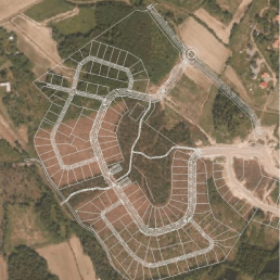
The Länsiniitty Suburb of Vaasa, Finland | Machine control
The Länsiniitty suburb of Vaasa is located a stone's throw from the rapidly growing Kivihaka shopping mall. This area will be completed in spring 2018, and it consists of about 150 residential or…
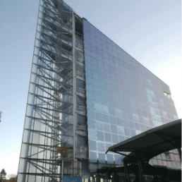
Hotel Scandic Vaasa | Infrastructure measurement
In 2017, the Wasacon construction company built a hotel at the corner of Rautatienkatu and Rosteninkatu in Vaasa. The 8-storey triangular-shaped tower with glass facade adds something new to the…
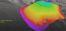
Jarmo Toikka Ky | UAV Aerial Photography
In the summer of 2017, we conducted UAV flight measurements for Jarmo Toikka Ky, a company specialising in earthworks. The customer wanted to find out the number of gravel piles in an area spanning…
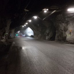
Malmberget | Gällivare | Mine measurement
The project has been about production measurements: mine drifts are marked where the drill rigs continue drilling according to pre-planned layouts. As the blasting progresses, the walls are surveyed…