Laser scanning and 3D measurement make reality digital
Laser scanning and point clouds: accurate data for smarter decisions
Laser scanning is a cutting-edge measurement technology that quickly and cost-efficiently captures vast amounts of 3D data, enabling the creation of highly detailed digital models of real-world environments. We offer laser scanning and 3D modeling services for everything from buildings, factories, and infrastructure to machines, production lines, bridges, and landscapes.
Laser scanning and 3d modeling technology are widely used across construction, real estate, industrial, infrastructure, and energy sectors. Whether you’re planning new developments, documenting existing structures, or mapping out production systems, laser scanning delivers fast, contactless, and highly reliable results. From the very first scan, you’ll have a complete dataset that helps you make better decisions, save time, and reduce the risk of costly errors.
At Ostromap, we specialize in laser scanning. With over 20 years of experience in precision measurement and deep technical expertise, we ensure every project is executed with the highest level of accuracy.
What is laser scanning?
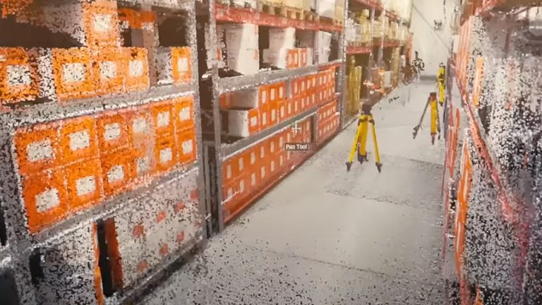
Laser scanning works by emitting millions of laser pulses into the surrounding environment. When these pulses hit a surface, they bounce back to the scanner, which calculates the distance to each object based on the time it takes for the pulses to return. Each pulse becomes a data point within a coordinate system. These points collectively form what’s known as a point cloud—a three-dimensional digital representation of the scanned environment. We use this data to create detailed 3D models or BIM models.
All services
From point clouds to 3D models and BIM: turning raw data into real value
Using the data from the point cloud, we build 3D models that accurately replicate the scanned environment. These models can be used for visualization, measurement, planning, documentation, or as the foundation for further design work. These precise 3D models reflect every wall, pipe, and detail exactly as they exist in reality, helping you avoid costly surprises. You get accurate dimensions from the start, identify potential issues early, and eliminate the need for rework, saving both time and money.
BIM, or Building Information Modeling, goes one step further. A BIM model is an intelligent 3D representation that includes not just geometry, but detailed information about each building component. With BIM, you gain a powerful tool for design, coordination, analysis, and facility management. It provides a visual model as well as a data-rich database containing material specifications, dimensions, functions, and precise locations. This allows you to generate reports, simulate changes, and detect clashes between systems before construction even begins.
Our services: laser scanning, point clouds, and 3D modeling
At Ostromap, we offer a wide range of services to capture and visualize reality with the highest possible precision. Using advanced measurement technologies such as laser scanning, UAV, and LiDAR, we deliver everything from 3D models to as-built scans, always tailored to meet your specific needs.
3D-mallit
Accurate 3D models based on laser scanning and point clouds — a reliable foundation for design and visualization.
Digital Twins
A digital mirror of reality, ideal for analysis, planning, and simulation.
BIM Models
All project information consolidated in a BIM model to support everything from design and coordination to operation and maintenance.
Reality Capture
Capturing reality down to the finest detail using advanced measurement technology and 3D documentation.
As-built Scanning
Documentation of the actual conditions for quality assurance, verification, and follow-up.
UAV and LIDAR
Fast and detailed data collection from the air, perfect for large areas and hard-to-reach terrain.
Laser scanning and 3D modeling streamline your projects by saving time, reducing costs, and improving efficiency
Compared to traditional surveying methods, laser scanning and 3D modeling offer major advantages: they deliver greater accuracy, faster results, and better cost-efficiency. In addition, digital 3D models simplify communication between companies, teams, and partners, helping streamline workflows and improve project outcomes.
Benefits for the construction industry: you can skip the slow, manual process of measuring and drawing. Instead, you get precise digital data that makes planning and design much easier. Because the 3D models are digital, they can be used throughout the entire construction process, from early design stages to final delivery and ongoing maintenance.
Benefits for the manufacturing industry: accurate measurements allow you to create digital twins of facilities, making it easier to plan installations of new machines or replace existing components. 3D models can also be used to verify that all parts of a production process are working as intended. For large-scale renovations, 3D models help you visualize changes and plan more efficiently.
How laser scanning works: the process, step by step
We carry out laser scanning in several stages, from careful planning to the delivery of usable results such as 3D models, drawings, or visualizations. Here’s an overview of the typical process:
1. Preparation and planning
We start by reviewing which surfaces or objects need to be scanned, what type of data is required, and what outcome the client expects. Based on this, we plan the number of scanning positions and assess technical requirements, such as the required level of detail or whether the data needs to be aligned to a specific coordinate system. We also estimate time and equipment needs accordingly.
2. On-site data collection
Once the planning stage is complete, we begin the scanning process. We place the 3D laser scanner at strategically selected positions around the object or environment. To ensure complete coverage, we always scan with overlapping positions, allowing the data to be merged into a unified point cloud during post-processing.
3. Point cloud processing and registration
After collecting the data, we process all scans to create a complete point cloud. This point cloud can then be converted into the file format that best suits the client’s needs, such as formats for CAD or BIM applications.
4. Georeferencing and coordinate adjustment
If the project requires alignment to a specific coordinate system, we conduct geodetic measurements on-site. Field reference points are used to position the point cloud accurately in relation to its surroundings. This allows the data to be integrated into broader contexts, such as road planning, building design, or infrastructure development.
5. Delivery of results
Finally, the point cloud is further refined based on the client’s requirements. The deliverables may include drawings, 3D models, cross-sections, elevation profiles, terrain models, or visualizations.

Information models: simplifying both design and maintenance
With a Building Information Model (BIM), data collected through laser scanning is transformed into an accurate 3D model of anything from buildings to industrial sites. Through the Scan to BIM process, you receive an information-rich model containing detailed geometric and visual data, supporting you throughout the entire project lifecycle, from planning and analysis to construction and long-term maintenance.
Contact us
Our projects in laser scanning, point clouds, and 3D modeling
With advanced laser scanning and 3D modeling, we help clients in construction, manufacturing, transportation, and forestry make faster, safer, and more informed decisions. Here are some examples of how our laser scanning solutions have made a real difference in our clients’ projects.
13.3.2024
Case 1: Sagan om ett industriföretag
13.3.2024
Case 2: Laserskanning av skogsbruk
13.3.2024
Case 3: TietoEvry skannar hela sin verksamhet
Frequently asked questions about laser scanning, 3D models, and point clouds
What are the advantages of laser scanning? What formats do we deliver 3D models in? Here you will find the answers to the most frequently asked questions about 3D laser scanning, 3D models and point clouds. Do you have a question that you cannot find an answer to here? Contact us!
What is laser scanning?
Laser scanning is a measurement method that uses laser pulses to quickly and accurately capture the shape of surrounding surfaces and objects. The scanner emits laser pulses that reflect back when they hit a surface. By measuring how long it takes each pulse to return, the system calculates the distance to the object.
During a scan, millions of data points are collected, forming a point cloud, which is a highly detailed 3D representation of the scanned object or environment. Based on the point cloud, we create 3D models tailored to your needs, which can be used for design, construction, or renovation planning.
What are the benefits of laser scanning?
Laser scanning is an efficient measuring technique for quickly capturing precise and detailed representations of real-world environments or objects. Laser scanning is widely used across various industries and offers several advantages over traditional surveying methods, especially in projects where time, accuracy, and collaboration are critical.
Key benefits of laser scanning:
- High precision: Laser scanning collects data with millimeter accuracy, making it ideal for planning, analysis, and manufacturing, especially in sectors like manufacturing, where small deviations can have large impacts.
- Speed: Laser scanning is significantly faster than traditional measurement methods, saving both time and money.
- Minimized errors: Accurate data reduces the risk of measurement errors and unnecessary rework.
- Visual clarity: Digital 3D models and point clouds offer an easily understandable visual of the real-world environment.
- Non-contact measurement: 3D scanning can be done from a distance, making it suitable for hard-to-reach or hazardous areas, such as high places, confined spaces, or industrial zones.
- Improved communication: Digital 3D models and BIM models enhance collaboration and understanding among project stakeholders.
What file formats do we use for 3D models and BIM models?
We tailor all 3D models and BIM models to fit each client’s specific needs and workflows. This means we can deliver files that integrate directly into your project, regardless of the platform or software you’re using. We follow established BIM industry standards and adjust the level of detail according to your requirements.
We deliver in formats such as:
- Point cloud data: e57, las, pts, ptx, pod, rcp, dxf, dwg
- 3D models and BIM models: dwg, rvt (Revit), Archicad, IFC, DGN, SAT
What is BIM in the context of laser scanning?
When combining laser scanning with BIM (Building Information Modeling), we don’t just create an accurate 3D model—we build a digital twin of the real world, enriched with valuable information. This information model serves as a foundation for smarter decisions in planning, remodeling, coordination, and facility management.
A BIM model may include:
- Material specifications: such as concrete, steel, wood, or glass with defined properties
- Dimensions and volumes: exact measurements and surface/volume data for all building components
- Installation details: layouts for electrical, plumbing, HVAC systems
- Maintenance data: e.g., installation dates, service intervals, and responsible parties
- Energy data: insulation values, energy class, thermal performance, and more
What does Scan to BIM mean?
Scan to BIM is the process of using a laser scanner to capture an accurate 3D scan of a building or environment. The measurement data is imported into a 3D modeling environment, where we create a detailed BIM model.
BIM (Building Information Modeling) means you don’t just get a 3D visual of the structure—you also get a model filled with essential data about the building’s components, such as material, dimensions, and function.
With Scan to BIM, you gain both a visual representation and a structured database, all in one place. This enables efficient analysis, planning, and visualization of your building projects, simplifying both collaboration and decision-making.
A family-owned company delivering future-proof measuring services across the Nordics
We are a family-owned business with deep expertise in laser scanning, 3D modeling, and BIM modeling. With over 20 years of industry experience, companies across the Nordic region trust us to deliver innovative, future-proof measuring solutions. When you work with us, you gain a reliable partner who supports you throughout the entire process, from measurement and modeling to documentation and ongoing maintenance.
About us
Want to learn more about our measurement services? Get in touch!

Henrik Aho
Sales and development
henrik.aho@ostromap.fi
050 490 2087

Anders Björklund
Measurement consultant | Laser scanning
anders.bjorklund@ostromap.fi
050 363 9843